Price: SOLD
SKU: 32284
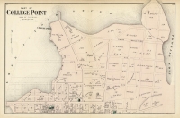
ARTIST: F. W. Beers
PUBLISHER: Published by Beers, Comstock & Cline, New York.
MEDIUM: Hand colored engraving.
DATE: 1873
EDITION SIZE: PS 23 3/4 x 15 1/2" (605 x 395 mm).
DESCRIPTION: Long Island City, Queens Co., L.I. (F. W. Beers) This map, created by F. W. Beers, offers a detailed view of Long Island City in Queens County, capturing its distinct geographical layout during the late 19th century. It showcases the intricate network of streets, individual property lines, and notable landmarks, which paints a vivid picture of the area’s residential and commercial development at that time. The map serves as a crucial historical document, providing insights into the urban planning and land use decisions that shaped Long Island City during a period of significant growth and transformation. Historically, Long Island City was a critical industrial and transportation hub, a status that is emphasized by this map’s detailed portrayal of rail lines and proximity to waterways, facilitating easy access to Manhattan and other parts of New York. The map not only reflects the physical landscape but also offers a glimpse into the economic and social dynamics of the era. As a part of Queens, it highlights the expansion and integration of outlying areas into the greater urban fabric of New York City, marking an important phase in the city’s push towards becoming a major metropolitan center.
ADDITIONAL INFO:
CONDITION: Good condition and color.
REFERENCE:


 Login / Register
 Basket

![Adams. [and] Hancock. [Towns of].](https://oldprintshop.com/uploads/jpg/24298_productthumb.jpg)