Price: $195.00
SKU: 38546
ARTIST: Merritt Hyde
PUBLISHER: Published by E. Belcher Hyde, New York.
MEDIUM: Stone engraving,
DATE: 1916.
EDITION SIZE: 14 1/2 x 24 1/2" (367 x 624 mm) plus margins.
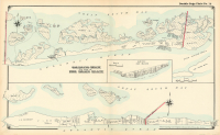
DESCRIPTION: This map is covers an area east of Sebonac Creek, (includes National Golf Links club) eastward to Wooley's Pond. Includes North Sea and Cow Neck. Inset map on left shows a section of the Westhampton Beach (Dune road) south of Speonk Point. Some property lines and landowners names are given. This map is from "Atlas of a part of Suffolk County, Long Island…."
ADDITIONAL INFO: Hand coloring varies from image here.
CONDITION: Good condition.
REFERENCE:


 Login / Register
 Basket
")