ARTIST: Jacques Bellin
PUBLISHER: Published by Jean Francois de La Harpe, Paris.
MEDIUM: Copper plate engraving,
DATE: c.1754.
EDITION SIZE: Image 8 3/8 x 6" (21.1 x 15.4 cm).
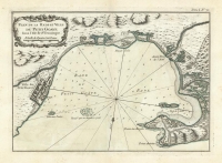
DESCRIPTION: Bellins close up map of Mexico City as it was built, or rebuilt by the Spanish after their conquest of Tenochtitlan. This map appeared in Prevost's "L'Histoire Generale des Voyages".<br><br> The cartographer Jacques Nicolas Bellin (1703-1772) was one of the most important and proficient French cartographers of the eighteenth century. He was appointed the first Ingenieur Hydrographe de la Marine, and also the Official Hydrographer to the French King. <br><br>
ADDITIONAL INFO:
CONDITION: Good condition. Black and white.
REFERENCE:


 Login / Register
 Basket