Price: $550.00
SKU: 71127
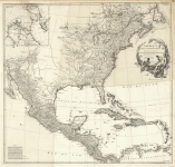
ARTIST: Jean Baptiste D'Anville
PUBLISHER: Published by the Homann Heirs, Nuremberg.
MEDIUM: Copper plate engraving,
DATE: 1756.
EDITION SIZE: Image size 17 3/4 x 19 3/4" (45.5 x 50.1 cm)
DESCRIPTION: A fine German produced map of the Colonies shown at the outset of the French & Indian War. Some of the interesting features include a truncated Pennsylvania and over sized Virginia. North Carolina is noted as “Earl Granvilles property” and extends westward past the Mississippi. Also shows a strangely shaped Georgia. Many Indian tribes are noted. The map is annotated in German. Cartographically, the map is based work of Jean Baptiste D'Anville.<br><br> First edition of two.
ADDITIONAL INFO: 1st edition of two.
CONDITION: Fair condition. Some damp stains within the map. Some worm holes in right half of map, in the ocean. Original outline color.
REFERENCE:


 Login / Register
 Basket