ARTIST: Samuel Augustus Mitchell
PUBLISHER: Published by William M. Bradley & Bros. Philadelphia.
MEDIUM: Stone engraving,
DATE: 1884-85.
EDITION SIZE: Image 20 x 14 1/2" (50.8 x 36.8 cm) plus margins.
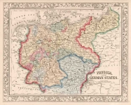
DESCRIPTION: An interesting early map of these two states. Each state is colored by county. Shows railroads, forts, buttes, mountain ranges, rivers, lakes, Indian reservations, and other details. This map appeared in Mitchell's "New General Atlas."
ADDITIONAL INFO:
CONDITION: Good condition and color.
REFERENCE:


 Login / Register
 Basket