Price: SOLD
SKU: 23093
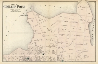
ARTIST: F. W. Beers
PUBLISHER: Published by Beers, Ellis and Soule. NY.
MEDIUM: Handcolored stone engraving,
DATE: 1867.
EDITION SIZE: Image size 15 7/8 x 12 3/4" (40.3 x 32.4 cm) plus margins.
DESCRIPTION: Plans of Westchester, West Farms, Morrisania Westchester Co., and Part of New York County (Now part of the Bronx) This detailed map from F. W. Beers' "Atlas of New York and Vicinity" showcases an intricate layout of what is now part of the Bronx, highlighting smaller neighborhoods such as Belmont, Bronxdale, Fordham, Kingsbridge, and Schuylerville and more. Along with the strategic location of Fort Schuyler at Throggs Neck. The map intricately outlines early roads, residential plots, property boundaries, and the names of property owners, offering a detailed visual representation of the area’s features during the late 19th century. Historically significant, this map captures a time when these neighborhoods were evolving from rural communities into more densely populated parts of New York City. The inclusion of detailed geographical and property ownership information makes it an invaluable resource for understanding the development patterns and land use changes in the Bronx area during the late 19th century, reflecting the broader urbanization trends of the region.
ADDITIONAL INFO:
CONDITION: Good condition with original color.
REFERENCE:


 Login / Register
 Basket
")
![Adams. [and] Hancock. [Towns of].](https://oldprintshop.com/uploads/jpg/24298_productthumb.jpg)