Price: SOLD
SKU: 37399
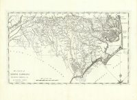
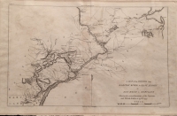
ARTIST: Samuel Lewis
PUBLISHER: Published in "The General Atlas," by Mathew Carey, Philadelphia.
MEDIUM: Copper plate engraving,
DATE: 1795-96.
EDITION SIZE: 17 1/2 x 11 1/8" (44.6 x 28.2 cm) plus title and margins.
DESCRIPTION: Mathew Carey of Philadelphia was the first major American publisher of maps and atlases. In 1795 he published "Carey's American Atlas," which was the first atlas drawn, engraved and published in America. This atlas contained 21 maps, primarily of American interest. Later in 1795 Carey produced "The General Atlas for Carey's Edition of Guthrie's Geography Improved" which contained the 21 American maps issued in the American Atlas as well as maps of the rest of the world. In 1796, Carey reissued "The General Atlas," dropping any mention of Guthrie and adding a large map of the U.S. by Samuel Lewis. This map appeared in the 1796 issue. Any of these maps are considered to be scarce in today's market. This map was drawn and engraved by Samuel Lewis. Lewis was one of the more intriguing American cartographers of the late 18th and early 19th centuries. He was responsible for drawing a number of maps that appeared in Carey's atlas as well as being the draftsman for the highly important 1814 map of Lewis and Clark's travels.
ADDITIONAL INFO:
CONDITION: Good condition. Original outline color.
REFERENCE: Wheat & Brun "Maps and Charts Published in America before 1800." #185


 Login / Register
 Basket