Price: $550.00
SKU: 44913
ARTIST: Didier Robert de Vaugondy
MEDIUM: Copper plate engraving,
DATE: 1750, (1783).
EDITION SIZE: Image size 18 7/8 x 23 1/8" (48 x 58.7 cm) plus margins.
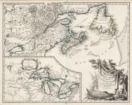
DESCRIPTION: Amérique Septentrionale, Robert de Vaugondy, 1783 This richly detailed map of North America, published by Robert de Vaugondy in 1783, reflects a major shift in global history—the recognition of the newly formed United States following the American Revolution. In this updated version of his earlier 1750 map, de Vaugondy outlines the United States in red, marking its western boundary at the Mississippi River in accordance with the Treaty of Paris signed that same year. The map includes colonial claims throughout the continent, with French, Spanish, British, and American territories carefully delineated. Rivers, mountain ranges, and major settlements are clearly engraved, offering a glimpse into how Europeans visualized the geography of the New World at the close of the 18th century. A key visual change in this edition is the movement of the decorative cartouche from the upper left to the upper right corner. In its original place, de Vaugondy has inserted a new inset titled "Partie Nord-Ouest de l'Amérique," which reflects the lingering uncertainties of the continent’s northwest. This inset includes speculative features drawn from 18th-century myth and rumor, most notably the imaginary Lac de Fonte or Sea of the West, a vast inland sea believed by some to offer a passage to the Pacific. The map captures a fascinating moment when political borders were being redrawn in real time, even as large parts of the continent remained unknown to European cartographers.
ADDITIONAL INFO: This piece is in a 22.75 x 28.5 inch archival mylar for handling.
CONDITION: Good condition. Original outline color.
REFERENCE:


 Login / Register
 Basket