Price: $150.00
SKU: 98904
ARTIST: Keith Johnston
PUBLISHER: Published by W. & A. K. Johnston, Edinburgh & London.
MEDIUM: Multi-stone lithograph
DATE: 1897.
EDITION SIZE: Two maps. image size each 17 1/4 x 22 1/2" (43.8 x 57..5 cm)
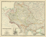
DESCRIPTION: A detailed pair of maps of Scotland that appeared in Johnston's "The Royal Atlas of Modern Geography." Inset maps include Edinburgh and Shetland Islands. Includes three keyed index sheets..
ADDITIONAL INFO: Sold as a pair.
CONDITION: Good condition and color save for some minor splitting along centerfold.
REFERENCE:


 Login / Register
 Basket
 Scotland southern sheet.")