Price: $200.00
SKU: 98995
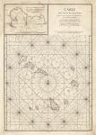
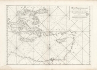
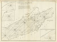
MEDIUM: Copper plate engraving
DATE: 1775
EDITION SIZE: Image size 18 7/8 x 26" (48 x 68.1 cm)
DESCRIPTION: This chart shows the eastern South African coast. It extends from Saldanha Bay past the Cape of Good Hope to north of Cape Courans, including the coasts of Natal and southern Mozambique, with insets of the bays of St. Blaise, Lagoa (Algoa Bay) and de Formose (Mossel) Bay. Based on the cartography of J d'Apres de Mannevillette. This map appeared in "Le Neptune oriental, dedie au roi /par M. d'Apres de Mannevillette. Paris / Brest.
ADDITIONAL INFO:
CONDITION: Good condition save for some faint damp staining in the side margins. B/W
REFERENCE:


 Login / Register
 Basket