ARTIST: J. H. Colton
PUBLISHER: Published by J .H. Colton, New York.
MEDIUM: Stone engraving,
DATE: 1861.
EDITION SIZE: Segmented case map. Overall 34 7/8 x 40 7/8" (88.4 x 10³/9 cm)
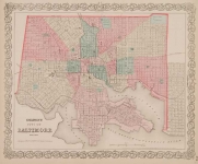
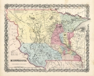
DESCRIPTION: A rare 1st edition Colton map of the United States issued in early 1861 showing the vast, scarcely populated West of the country, the year when new Territories of Colorado, Nevada, Dakota were created by Congress and existing borders of Utah, New Mexico, Nebraska, Kansas Territories were significantly modified - as shown on this map. Of greatest significance was the creation that year of Colorado Territory, carved out of eastern Utah, Kansas (the 6 unorganized western counties created on February 7, 1859 by the Kansas Territorial Legislature), Nebraska (Long’s Peak, Ft. St. Vrain and area north to Ft. Laramie), New Mexico (Spanish Peaks area). It replaced the unrecognized by Congress, but fully operational for 20 months, Territory of Jefferson created by Pike’s Peak gold miners on October 24, 1859 - with a Governor, elected Legislature, Courts. The capital was first located in Denver City then relocated in November 1860 to Golden City.<br><br> After the Civil War started, a 2nd edition of this map was issued in later 1861 with a slightly modified title “COLTON’S RAIL-ROAD AND MILITARY MAP OF THE UNITED STATES, MEXICO, THE WEST INDIES &c., NEW YORK. 1861.” A new large table showing population statistics for various States & Territories is inserted above the inset map. A new advertisement for “J.H. Colton’s Geographical Establishment” is engraved above the distance table on the right. Later, a 3rd edition was published in 1862 with a much less decorative border. <br><br> This 1861 J.H. Colton map was preceded by Carlos Butterfield’s map, from the same plate, titled: “MAP OF THE UNITED STATES AND MEXICO” in Butterfield’s 1860 “United States and Mexican Mail Steamship Line” It has a different inset map titled: Map showing the Routes of the Ocean Steamers. <br><br> Rumsey comments on this early 1861 J.H. Colton map: “Unusual medium size U.S., not seen before. <br><br> <strong>COLORADO. </strong> The new Territory was created by Congress on February 28, 1861. It replaced the illegal but fully functioning Territory of Jefferson whose Constitution and borders were approved by Pike’s Peak gold miners convention in October 1859 – the Constitution adopted October 6, 1859 and the territorial government elected on October 24, 1859. The Territory was divided into 12 counties organized on November 28, 1859 and at the beginning of 1861 a 13th, short-lived, Ni Wot County – carved out of 3 then existing Jefferson County mining districts: Bergen Park (now Evergreen), Conifer and Mt. Vernon. The Territory of Jefferson included all of the later Congressionally approved Colorado Territory but it was about 70% larger – its northern boundary was the 43rd parallel 138 miles north of Colorado Territory’s 41st parallel border, its eastern boundary was located about 2.7 miles farther east and the western boundary about 50 miles farther west than the Colorado Territory boundaries approved by Congress. On May 29, 1861, William Gilpin, the newly appointed Governor of Colorado Territory arrived in Denver. On June 6, 1861 Robert W. Steele, the Governor of the Territory of Jefferson, issued a Proclamation dissolving the Territory of Jefferson and urging all residents to abide by the laws governing the United States. J.H. Colton on this 1861 map of the United States removed Johnson & Browning’s vertical “COLONA” area name in previously eastern Utah and replaced it with a re-positioned more horizontal “COLORADO” Territory name. This is one of the earliest maps to show the Colorado Territory. <br><br> <strong>NEW MEXICO / ARIZONA.</strong> (The north-south configuration) In 1857 an 1856 proposal to establish Arizona Territory in southern New Mexico was defeated in Congress. In April 1860, the New Mexico territorial legislature called a convention on this matter. It met in Tucson and in July 1860 drafted a constitution for a "Territory of Arizona" to be split off New Mexico Territory south of the 34th parallel. However, Congress was still not interested at that time in approving this division, so it existed just as a proposed Territory until 1863. At the outbreak of the Civil War territorial secession conventions in that proposed Territory, called at Mesilla on March 16, 1861 and Tucson on March 28, 1861 adopted an ordinance of secession, established a provisional Arizona Territory with a government and petitioned the Confederate Congress for admission as a Territory. This Confederate “Territory of Arizona” was officially declared on August 1, 1861, following the Confederate victory at the Battle of Mesilla on July 25, 1861. However, Confederate hold in the area was soon broken after the Battle of Glorieta Pass on March 26-28, 1862. In July 1862 the government of Confederate Territory of Arizona relocated from Mesilla to El Paso, Texas, where it remained for the duration of the war. Thus, in reality a functioning Confederate Territory of Arizona existed for only 1 year under military occupation by the Confederacy - from the Battle of Mesilla on July 25, 1861 thru July 1862. J.H. Colton’s early 1861 map of the United States shows properly the undivided New Mexico Territory from the date Colorado Territory was created on February 28, 1861 thru the Battle of Mesilla on July 25, 1861 – before the Confederate Territory of Arizona was in place. The name “ARIZONA” in the southern part of New Mexico on maps was appropriate from July 1860 thru February 24, 1863 when Congress created Arizona Territory from the western, not southern, part of New Mexico. <br><br> <strong>NEVADA.</strong> Nevada Territory as shown on this 1861 J.H. Colton U.S. map is in its first state as created on March 2, 1861 just 3 days after Colorado Territory came into existence. The map shows Nevada Territory before the annexation by Nevada of western parts of Utah Territory on July 14, 1862 and then again on May 5, 1866, as well as annexation by Nevada of the north-western tip of Arizona Territory on January 18, 1867. A “NEVADA” name for this new Territory was engraved by J.H. Colton, absent on the Johnson & Browning map. <br><br> <strong>NEBRASKA.</strong> The Nebraska Territory boundaries on this map are shown after Dakota Territory was split off from the northern part on March 2, 1861 and on the same date small additions to this new, greatly reduced, Nebraska Territory were made from Washington and Utah Territories. It existed in this shape until March 3, 1863 when it farther lost its western part to the newly created Idaho Territory.<br><br> <strong>DAKOTA.</strong> The Dakota Territory with boundaries as shown on this 1861 J.H. Colton map was created on March 2, 1861 from the enormous prior Nebraska Territory. It existed in this shape until March 3, 1863 when Idaho Territory was split off.<br><br> <strong>WASHINGTON.</strong> The boundaries of Washington Territory shown on this J.H. Colton map are after Washington lost its small south-eastern tip to the reduced Nebraska Territory on March 2, 1861. It retained this shape until March 3, 1863 when Idaho Territory was split off.<br><br> <strong>KANSAS.</strong> Kansas State was created by Congress in the shape shown on this map on January 29, 1861, unchanged to this day. <br><br>
ADDITIONAL INFO:
CONDITION: Time toning throughout and small stain in upper right Pin holes in each corner where it was pined to a wall. Original hand coloring Overall a very nice example.
REFERENCE: Rumsey 2554.


 Login / Register
 Basket