Price: $200.00
SKU: 53654
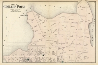
ARTIST: F. W. Beers
PUBLISHER: Published by Beers, Ellis and Soule, NY.
MEDIUM: Handcolored stone engraving,
DATE: 1867
EDITION SIZE: Image size 17 1/2 x 13" (44.5 x 33 cm).
DESCRIPTION: "Town of Norwalk, Fairfield Co. Conn." Featured in F. W. Beers' "Atlas of New York and Vicinity," this detailed map of the Town of Norwalk, Connecticut, vividly captures the early roads, railroads, homes, property lines, and owners' names, with an inset of Winnipauk. By highlighting the transportation routes and residential layouts of the late 19th century, the map provides a fascinating glimpse into Norwalk's development during a critical period of urban and industrial expansion. This historical depiction not only serves as an educational tool but also as a valuable resource for understanding how Norwalk transformed into the dynamic city it is today, making it accessible and impactful for audiences of all backgrounds.
ADDITIONAL INFO: This piece is in a 15.25 x 18.5 inch archival mylar for handling.
CONDITION: Good condition and color.
REFERENCE:


 Login / Register
 Basket

![Adams. [and] Hancock. [Towns of].](https://oldprintshop.com/uploads/jpg/24298_productthumb.jpg)