Price: $275.00
SKU: 43244
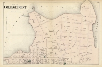
ARTIST: F. W. Beers
PUBLISHER: Published by Beers, Ellis and Soule. NY.
MEDIUM: Handcolored stone engraving,
DATE: 1867
EDITION SIZE: Image size 15 7/8 x 12 3/4" (40.3 x 32.4 cm) plus margins.
DESCRIPTION: This 1867 map of Westport, from Atlas of New York and Vicinity by F.W. Beers, presents a detailed view of the village. It highlights early roads, homes, and the names of their owners, offering valuable historical insight into the town’s development.
ADDITIONAL INFO: This piece is in a 15 x 20 inch archival mylar for handling.
CONDITION: Good condition and color.
REFERENCE:


 Login / Register
 Basket

![Adams. [and] Hancock. [Towns of].](https://oldprintshop.com/uploads/jpg/24298_productthumb.jpg)