Price: $195.00
SKU: 100034
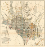
ARTIST: G. Fiebeger
PUBLISHER: Published by the U.S. Army Corps of Engineers.
MEDIUM: Stone engraving,
DATE: 1892.
EDITION SIZE: Image size 21 7/8 x 26 5/8" (55.7 x 67.7 cm).
DESCRIPTION: An interesting map of Washington D.C. showing the growth of the city into the suburbs. Identifies Reno, Wesley Heights, Fairview Heights Petworth, Brookland, Langdon, Woodbridge, Glendale, etc. Parks and institutions shown in green.
ADDITIONAL INFO:
CONDITION: Good condition..
REFERENCE:


 Login / Register
 Basket