Price: $145.00
SKU: 100097
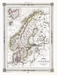
ARTIST: Alexandre Vuillemin
MEDIUM: Stone engraving,
DATE: c.1880.
EDITION SIZE: Image size 10 3/4 x 14 3/4" (27.3 x 37.5 cm) plus margins
DESCRIPTION: This map of the United States is from J. Migeon’s Géographie Universelle. Each state and territory is shown in a contrasting shade, with the country’s transportation network and known topography clearly delineated. Native American tribes, rivers, settlements, and railroads are marked throughout. In the lower left, a vignette illustration depicts the Capitol building in Washington, D.C.
ADDITIONAL INFO: This piece is in a 14.25 x 19.5 inch archival mylar for handling.
CONDITION: Good condition and color.
REFERENCE:


 Login / Register
 Basket
")