Price: $95.00
SKU: 25197
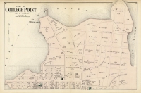
ARTIST: F. W. Beers
PUBLISHER: Published by Beers, Comstock & Cline, NY.
MEDIUM: Handcolored engraving,
DATE: 1873
EDITION SIZE: 14 1/4 x 10 1/2" (36.2 x 26.2 cm) plus margins.
DESCRIPTION: Shows many of the early rail lines and includes the towns of Bay Ridge, Fort Hamilton, Bath and Unionville. The large inset map shows a close up of the village of Bath. A detailed and nicely colored map from "Atlas of Long Island, New York. From recent and actual surveys and records."
ADDITIONAL INFO:
CONDITION: Good condition save for a couple of minor stains. Original hand coloring.
REFERENCE:


 Login / Register
 Basket

![Adams. [and] Hancock. [Towns of].](https://oldprintshop.com/uploads/jpg/24298_productthumb.jpg)