Price: $225.00
SKU: 100699
ARTIST: J. H. Colton
PUBLISHER: Published by J.H. Colton, New York.
MEDIUM: Stone engraving
DATE: 18755-60.
EDITION SIZE: Image 14 x 11 1/8" (35.4 x 28.2 cm) plus decorative border and margins.
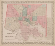
DESCRIPTION: A decorative and well engraved map for Boston from "Colton's General Atlas." Shows all the railroads coming into town. Beacon Street borders the Charles River. Streets, wharfs and public buildings are identified.<br><br> Throughout the 19th century the landmass of the city of Boston was constantly changing. This map shows Backbay largely filled in and roads being laid out but mostly not yet named.
ADDITIONAL INFO:
CONDITION: Good condition and color.
REFERENCE:


 Login / Register
 Basket