Price: $395.00
SKU: 25760
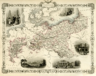
ARTIST: John Tallis
PUBLISHER: Published by the London Printing and Publishing Company.
MEDIUM: Steel plate engraving,
DATE: c.1851.
EDITION SIZE: Image size 9 1/2 x 13 1/4" (24.2 x 33.5 cm).
DESCRIPTION: A decorative map of the United States that includes two portraits, George Washington and Benjamin Franklin. Inset views are of a Buffalo Hunt, Penn’s treaty with the Indians, and Washington’s Monument. It shows a strangely configured Texas and New Mexico, a pre-Indian Territory region called Western Territory, a massive Missouri Territory, and a strangely elongated Nebraska Territory extending northward to Canada. This map is from "The Illustrated Atlas and Modern History of the World" Published by John Tallis, J. &. F. Tallis, or The London Printing and Publishing Company. The illustrations are drawn by J. Marchant & engraved by J. Rogers. The map is drawn and engraved by J. Rapkin.
ADDITIONAL INFO:
CONDITION: Good condition. Original outline handcoloring.
REFERENCE:


 Login / Register
 Basket