Price: SOLD
SKU: 81546
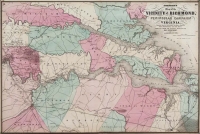
ARTIST: A. Johnson
PUBLISHER: Published by Johnson and Ward. New York.
MEDIUM: Engraving handcolored,
DATE: 1865-66
EDITION SIZE: 15 1/2 x 21 9/16" (393 x 546 mm) plus decorative border.
DESCRIPTION: From Johnson's "New Illustrated Family Atlas of the World....". Montana in its first years as a distinct territory, shown with 9 counties. One of the earliest maps to show the proposed territory of Wyoming. Other interesting details are the inclusion of the "Emigrant Road" (Oregon and Mormon Trail) and the future route of the Pacific Railroad link. By 1868 both the new territory of Wyoming and the transcontinental railroad were a reality.
ADDITIONAL INFO:
CONDITION: Good condition save for some minor foxing. Original outline coloring.
REFERENCE:


 Login / Register
 Basket