Price: $200.00
SKU: 101914
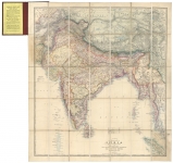
ARTIST: Edward Stanford
PUBLISHER: London. Edward Stanford,55 Charing Cross.
MEDIUM: Engraving, hand colored,
DATE: 1874.
EDITION SIZE: Image size 12 3/8 x 15 3/4" (31.5 x 40 cm).
DESCRIPTION: A highly detailed map of the routes and roads through the region.<br><br> This map appeared in "The Complete Atlas of Modern Classical and Celestial Maps,... Constructed and engraved on steel, under the superintendence of the Society for the Diffusion of Useful Knowledge...".<br><br> The Society for the Diffusion of Useful Knowledge, aka SDUK, was an English enterprise devoted to spreading the most up to date cartographic information and enhancing geographical understanding and knowledge of the world. Over a period of years, the maps that the SDUK produced were issued by various publishers. The following is a breakdown. Baldwin & Craddock, 1829-36. Chapman & Hall, 1844. C. Knight, 1844-52. G. Cox, 1852-3. Stanford, 1857-74. The maps from this series are known for their fine engraved quality and attention to detail.
ADDITIONAL INFO:
CONDITION: Good condition with original outline color. Small stain in lower left margin.
REFERENCE:


 Login / Register
 Basket