Price: $275.00
SKU: 56652
ARTIST: A. Johnson
PUBLISHER: Published by A.J. Johnson, New York.
MEDIUM: Engraving handcolored,
DATE: 1864-1866.
EDITION SIZE: Image size 17 x 23 1/2" (43 x 59.6 cm).
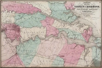
DESCRIPTION: From "Johnson's New Illustrated Family Atlas". Nevada has its lower corner truncated, leaving Las Vegas in Arizona. Dated 1864 near the bottom of the sheet, but this particular example was originally published in 1866 as part of Alvin Jewitt Johnson’s Illustrated Family Atlas. Version 4.0 on Ira Lourie’s Johnson Map Project, the first to name Yavapai County. in Arizona. In addition to locating towns, Indian tribes and topographical features, the map shows the mail route and proposed railroads.
ADDITIONAL INFO:
CONDITION: Good condition and color.
REFERENCE:


 Login / Register
 Basket