Price: SOLD
SKU: 102031
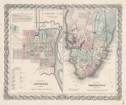
ARTIST: J. H. Colton
PUBLISHER: Published by J. H. Colton, 172 William Street, New York.
MEDIUM: Stone engraving, hand-colored,
DATE: 1855-1856.
EDITION SIZE: Image size 14 3/4 x 24 1/2" (37.4 x 62.3 cm)
DESCRIPTION: Map of New York and the Adjacent Cities (Manhattan) This decorative map, created by J. H. Colton and featured in "Colton's General Atlas," offers a well-engraved depiction of Manhattan, elegantly capturing its urban layout. It includes detailed parts of Jersey City, Hoboken, Brooklyn, Greenpoint, and Long Island City, with an inset in the lower right corner that meticulously shows the northern tip of the island, providing a comprehensive view of this bustling metropolis. Historically, this map represents an era of rapid growth and transformation for New York City during the mid-19th century. It serves as a valuable historical document, highlighting the expansion of urban areas and the evolving geography that shaped the city's development. By including adjacent cities, the map highlights the interconnected nature of the region and its significance as a thriving hub of commerce, culture, and community.
ADDITIONAL INFO: This piece is in a 18.75 x 28.5 inch archival mylar for handling.
CONDITION: Good condition. Fine original hand coloring.
REFERENCE:


 Login / Register
 Basket
.")