Price: SOLD
SKU: 26035
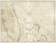
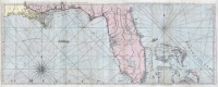
ARTIST: Thomas Jefferys
PUBLISHER: London, Printed by Robt. Sayer & J. Bennett, Map and Printsellers...
MEDIUM: Copper plate engraving with outline color,
DATE: 1775
EDITION SIZE: 26 3/4 x 52 1/2" (68 x 138 cm) plus margins.
DESCRIPTION: A fine large-scale map of the state from Thomas Jeffreys' "The American Atlas." Likely the most detailed map of the state before Reading Howell’s map of 1792.
ADDITIONAL INFO: Atlas now broken (HSN-Alex conversation 5/2/21)
CONDITION:
REFERENCE:


 Login / Register
 Basket