Price: $45.00
SKU: 30867
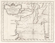
ARTIST: Gio. Tommaso Masi
MEDIUM: Copper plate engraving,
DATE: 1763.
EDITION SIZE: 8 1/2 x 11 1/2" (21.8 x 29.4 cm) plus margins.
DESCRIPTION: The "Carta rappresentante l'Isola della Martinicca" (translated as "Map Representing the Island of Martinique") is an Italian map from 1763, depicting the Caribbean island of Martinique during the late colonial period. The map details the island’s coastal features, settlements, forts, and geographical landmarks, reflecting its importance as a French colony. <br><br> By 1763, Martinique had been a strategic center for sugar production and trade, frequently contested by European powers, particularly during the Seven Years' War (1756–1763). The Treaty of Paris (1763) ultimately restored Martinique to French control after British occupation.
ADDITIONAL INFO: This piece is in a 13 x 16 inch archival mylar for handling.
CONDITION: Condition is fair, with vertical creasing throughout the image. There are bookworm marks on the top margins and the right corner margin. The margins have been trimmed.
REFERENCE:


 Login / Register
 Basket