Price: SOLD
SKU: 25192
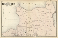
ARTIST: F. W. Beers
PUBLISHER: Published by Beers, Comstock & Cline, NY.
MEDIUM: Handcolored engraving,
DATE: 1873.
EDITION SIZE: 14 1/2 x 23 5/8" (36.8 x 60 cm) plus margins.
DESCRIPTION: "The City of Brooklyn," a vibrant map featured in the "Atlas of Long Island, New York. From recent and actual surveys and records," provides a detailed and colorful depiction of the area from Newtown Creek to Sunset Park. This map captures the intricate urban and architectural details of Brooklyn during its transformational phase in the late 19th century. As Brooklyn transitioned from a collection of small towns into a unified urban landscape, this map meticulously documented its streets, landmarks, and burgeoning neighborhoods, showcasing the region's evolution towards becoming an integral part of New York City. By detailing the precise layout of streets, parks, and significant buildings of the era, the map provides invaluable insights into the urban planning and community life of the time. It stands as both a crucial educational tool for those interested in urban development and a fascinating artifact for anyone eager to explore the historical layers that have shaped Brooklyn's unique character.
ADDITIONAL INFO: This piece is in a 16.5 x 25.5 inch archival mylar for handling.
CONDITION: Good Condition and color on the map
REFERENCE:


 Login / Register
 Basket

![Adams. [and] Hancock. [Towns of].](https://oldprintshop.com/uploads/jpg/24298_productthumb.jpg)