Price: SOLD
SKU: 32009
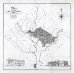
ARTIST: Andrew Ellicott
MEDIUM: Copper plate engraving,
DATE: 1792.
EDITION SIZE: Image size 20 1/2 x 27 7/8" (52.2 x 70.8 cm).
DESCRIPTION: The first "official" plan of the Nations New Capital.<br><br> On January 24, 1791, President George Washington announced the Congressionally designated permanent location of the national capital, a diamond-shaped ten-mile tract at the confluence of the Potomac and Eastern Branch Rivers. The original survey of the 100 square mile diamond shaped "district" was undertaken by Andrew Ellicott and Benjamin Banneker (a free slave). In March of 1791, Major Pierre Charles L'Enfant was appointed by George Washington to prepare the plan for the city itself with Ellicott as his assistant. Unfortunately, L'Enfant turned out to be very difficult to work with. Eventually both Washington and Jefferson became disgusted with L'Enfant's obstinacy which led to his being suspended in 1792 and outright termination in 1793. Ellicott took over the project using L'Enfants plan as a base. The Philadelphia engravers, James Thackera & John Vallance and Samuel Blodget Jr. were hired to produce engraved versions. Blodget arranged for Samuel Hill of Boston to engrave the map for him. Both Hill and Thackera & Vallance produced a large "official" map of the new "federal city" as well as two small, almost virtually identical maps. This is the large Thackera & Vallance engraving and is referred to as the first "official" plan. Georgetown is also well delineated.
ADDITIONAL INFO: Framed a large black & guilt scoop molding. Overall framed side 38 x 35 inches.
CONDITION: Good condition save for some minor repair in the upper right and left corners Occasional short tear along sheet edges.
REFERENCE: Verner 6.


 Login / Register
 Basket