Price: SOLD
SKU: 102446
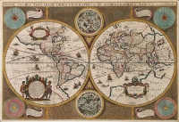
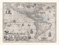
ARTIST: Jodocus Hondius
MEDIUM: Copper plate engraving
DATE: 1618 (1636)
EDITION SIZE: Image size 14 3/4 x 19 1/2" (37.6 x 59.7 cm) plus margins.
DESCRIPTION: A rare English text edition of one of the great maps of the America's<br><br> This important map of the Americas was first published in 1618 by Jodocus Hondius. Cartographically, this map influenced a generation of cartographers and served as the basis for understanding the Americas for the first half of the 17th century. When first issued, the map was surrounded by four panels, figures on the sides, and Views on the top and bottom. The plate was trimmed, removing the panels by Henricus Hondius c.1630. The map had a long life, appearing in atlases up to 1665, first by Hondius and then by his son-in-law, Jan Janson.<br><br> The insets show us the theorized contours of the North and South Polar regions. Embellished with images of sea monsters and sailing galleons.
ADDITIONAL INFO: The is a rare English text imprint, "page 435 9.P" It only appeared in editions of 1636, 1638 and 1641.<br><br> Image of verso can be sent upon request.
CONDITION: Good condition save for a faint matline. Hand colored.
REFERENCE: Burden 192


 Login / Register
 Basket