Price: $180.00
SKU: 102514
ARTIST: Jean Buchon
PUBLISHER: Published by J. Buchon, Paris.
MEDIUM: Engraving,
DATE: 1825
EDITION SIZE: Image size 17 1/4 x 24" (43.6 x 61.2 cm) including text.
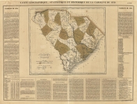
DESCRIPTION: This map, "Carte Géographique, Statistique et Historique de la Jamaïque" by Jean Alexandre Buchon, published in 1825, is a richly detailed and visually striking map of Jamaica that offers both geographic precision and historical insight. Issued as part of the French edition of Carey & Lea’s celebrated atlas, A Complete Historical, Chronological, and Geographical American Atlas, this map reflects early 19th-century European interest in the Caribbean and the broader Americas. Buchon’s work is particularly prized for its elegant layout, combining cartography with in-depth commentary, and was part of a series that presented updated political and geographic knowledge to a rapidly modernizing world. The map itself is hand-colored to show the island’s parishes, and is filled with fine detail—rivers, roads, towns, ports, and natural features are all clearly marked. Surrounding the map is a panel of French text describing the island’s geography, climate, trade, and the key waterways that shaped its development. Both decorative and informative, this map serves not only as a valuable historical document but as an attractive piece for collectors interested in colonial-era cartography and the visual storytelling of one of the Caribbean’s most strategically significant islands.
ADDITIONAL INFO: This piece is in a 20.75 x 28.inch archival mylar for handling.
CONDITION: Good Conditon, small fold on the top left margin of the print
REFERENCE:


 Login / Register
 Basket