Price: SOLD
SKU: 102801
ARTIST: Conrad Malte-Brun
PUBLISHER: Published in Paris. Chez Francois Buisson, Rue Gilles-Coeur.
MEDIUM: Engraved atlas.
DATE: 1810
EDITION SIZE: Large quarto, 14 1/4 x 10 3/4"" (36.3 x 27 cm)
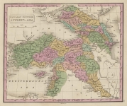
DESCRIPTION: A bright and clean example of one of the finest and most under-appreciated World atlases.<br><br> This atlas calls for 24 maps, all present, with most being dated 1809. By the 1812 edition, the majority of the maps were changed, with the dates removed and occasional changes within the map. As an example, the 1821 printing of the North America map incorporates from the travels of Lewis and Clark At the end of the volume are an additional five maps, Europe, France, Germany Poland and "Pas-Bas" or Holland which are all dated 1829. Conrad Malte-Brun, a Danish born mapmaker, was one of the most influential French mapmakers of the first half of the 19th Century.
ADDITIONAL INFO:
CONDITION: The condition is very good, the majority of the first 24 maps are on untrimmed deckle edge paper and have outline color. Original binding.
REFERENCE:


 Login / Register
 Basket