Price: $7,000.00
SKU: 8236
ARTIST: Hermann Moll
PUBLISHER: Published by H. Moll, London.
MEDIUM: Copper plate engraving,
DATE: c.1720.
SIZE: Image size 23 7/8 x 40" (60.6 x 101.6 cm)
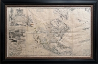
DESCRIPTION: A fine map showing the early Colonial boundaries claimed by Britain, France, and Spain.<br><br> Being an English-produced map, particular emphasis on the British claims is shown especially in the south east where the French were encroaching on English property claims. The inset view in the upper left shows the Indian fort "Sasquesahanok" which was located on the Susquehanna River in Pennsylvania. Moll's map was originally published in1718, soon after the publication of Delisle's 1718 map of the Mississippi Valley. At first glance it appears that Moll copied Delisle's 1718 Carte de la Louisiane et cours du Mississip . . . . Moll actually enlarged Delisle and attacks the veracity of the French claims in America as reflected in Delisle's map. Wm. Cumming notes "Moll calls upon the English noblemen, gentlemen, and merchants interested in Carolina to note the 'Incroachments' of the French map on their 'Properties' and on the land of their Indian allies. The map presents details of the Southeast found in no other printed map. The chief source of this information is a large, unsigned, undated manuscript map in the Public Record Office, from which Moll took much information on trading paths, Indian tribes, French, Spanish, and English forts, settlements, rivers, and other topographical data." The present edition lists the names of Moll, John King, Thomas Bowles, and John Bowles.
ADDITIONAL INFO: Nicely framed in a 3" receding black with sanded spandrel molding. Overall framed size, 30 x 45.5 inches.
CONDITION: Good condition. Original outline hand coloring.
REFERENCE: McLaughlin,"California as an Island, 197; Leighly 180; Cumming, pp.43-44; Reinhartz, Herman Moll, Geographer: An Early Eighteenth-Century European View of the American Southwest, pp. 32-33 in Reinhartz & Colley (eds.)



 Login / Register
 Basket