Price: $450.00
SKU: 20677
ARTIST: Thomas Jefferys
PUBLISHER: London, Printed for & Sold by Robt. Sayer & Jn. Bennett, No. 53, in Fleet Street.
MEDIUM: Copper plate engraving with outline color,
DATE: 1775
EDITION SIZE: Image size 24 1/2 x 19 1/8" (613 x 495 mm) plus margins.
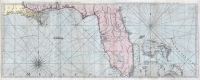
DESCRIPTION: This charts features the Islands in the Gulf of St. Laurence, Isle of Anticosti, Magdalen Islands Saint John and Cape Breton. This map appeared in Thomas Jefferys' "The American Atlas" and is numbered in the upper right in Roman numerals XI. First state of four.
ADDITIONAL INFO:
CONDITION: Good condition. Original outline coloring.
REFERENCE: Kershaw II #597


 Login / Register
 Basket