Price: $750.00
SKU: 50590
ARTIST: J. H. Colton
PUBLISHER: Published by G. W. & C. B. Colton & Co. No 172 William St. New York.
MEDIUM: Stone engraving,
DATE: 1873
EDITION SIZE: Image size 11 1/8 x 13 5/8" (28.3 x 34.7 cm) plus decorative scrollwork border and margins.
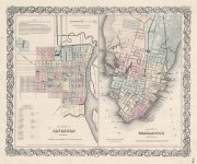
DESCRIPTION: A separately issues pocket map of these two states.<br><br> In the upper right are two inset maps, "Richmond, Henrico County. Manchester and Springhill, Chesterfield Co." and "Norfolk, Portsmouth and Gosport." A relatively early map to show West Virginia. In 1861 at the outbreak of the American Civil War the Virginia was politically split; the eastern portion was aligned with the Confederacy and the western regions with the north. In 1863, West Virginia was admitted to the Union as a new separate state.
ADDITIONAL INFO: A very nice example of the map.
CONDITION: Very good condition. Original hand coloring.
REFERENCE:


 Login / Register
 Basket