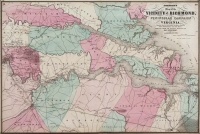
Price: $225.00
SKU: 9809
ARTIST: A. Johnson
PUBLISHER: Published by Johnson and Ward.
MEDIUM: Engraving handcolored,
DATE: 1864
SIZE: 15 9/16 x 21 7/8" (39.4 x 54.6 cm) plus engraved decorative border and margins.
DESCRIPTION: West Virginia, admitted to the Union in 1863, was formed when the western most counties of what had been Virginia voted against secession. Engraved vignettes include Fortress Monroe, the University of Virginia and some Washington, DC buildings.<br><br> This map appeared in Johnson's "New Illustrated (Steel Plate) Family Atlas, With Physical Geography, And With Descriptions Geographical, Statistical, And Historical...".
ADDITIONAL INFO:
CONDITION: Good condition and color save for some fait damp staining along lower edge.
REFERENCE:



 Login / Register
 Basket