Price: $225.00
SKU: 104689
ARTIST: George Anson
MEDIUM: Copper plate engraving
DATE: c. 1750.
SIZE: Image size 10 x 15 1/4" (25.2 x 38.7 cm)
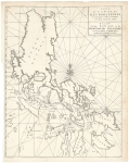
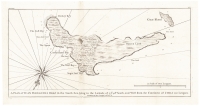
DESCRIPTION: Plan of Manila Bay in the Philippines and the Port of Acapulco, in Mexico. With a profile view of the Ladrone Islands (Mariana Islands). This map appeared in one of the editions of Anson's A voyage round the world, in the years MDCCXL, I, II, III, IV, an account of his circumnavigation.<br><br> Commodore George Anson led a British naval squadron of eight ships around the world between 1740 and 1744 during the War of Jenkins' Ear. The mission aimed to attack Spanish possessions in the Pacific. It succeeded in capturing a rich Spanish treasure galleon, but suffered catastrophic losses from scurvy, storms, and shipwrecks, with only one ship and a small fraction of the crew surviving.<br><br>
ADDITIONAL INFO:
CONDITION: Good condition save for a few small worm holes. B/W.
REFERENCE:



 Login / Register
 Basket