Price: $275.00
SKU: 105035
ARTIST: Jean Francois Galoup La Perouse
MEDIUM: Copper plate engraving.
DATE: 1797.
SIZE: Image size 19 1/2 x 27" (49.5 x 68.8 cm)
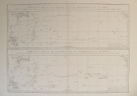
DESCRIPTION: This map shows the islands off the southern end of Korea.br><br> This chart appeared in Jean-Francois de La Perouse “Atlas du Voyage de la Perouse.“<br><br> Jean-Francois de Galoup, Comte de La Perouse (1741-88) led a French scientific expedition to the Pacific in 1785-88. He was one of the most noted naval commanders and navigators in France and was selected by King Louis XVI to complete Captain James Cook’s exploration of the western Pacific. In a rare moment of co-operation, the British Admiralty furnished scientific equipment to measure variations in magnetic north and for determining longitude. Fortunately for us La Perouse was meticulous in sending copies of his detailed logs and surveying via other ships as well as overland. His last contact was in the spring of 1788 with a British ship in Botany Bay, Australia. The expedition was never heard from again. When the French Government realized that it had been lost, they decided to publish an account as in many other ways it is regarded as one the greatest French voyages of exploration. It was not until 1827 that their fate was known. They had been shipwrecked on the island of Vanikoro and many of the survivors were killed. Engraved by Herault.<br><br>
ADDITIONAL INFO:
CONDITION: Good condition. B/W
REFERENCE:



 Login / Register
 Basket