Price: $375.00
SKU: 25193
ARTIST: F. W. Beers
PUBLISHER: Published by Beers, Comstock & Cline, NY.
MEDIUM: Handcolored engraving,
DATE: 1873
SIZE: 13 7/8 x 22 1/2" (352 x 569 mm) plus margins.
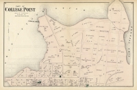
DESCRIPTION: A detailed and nicely colored map of Manhattan, Brooklyn and Long Island City. This map appeared in "Atlas of Long Island, New York. From recent and actual surveys and records."
ADDITIONAL INFO:
CONDITION: Good condition and color.
REFERENCE:



 Login / Register
 Basket