Price: $425.00
SKU: 105186
ARTIST: John Wood
PUBLISHER: Published by the Proprietor Canaan & Wm. Swinton 60 Princes St. & J. Richie High St. Edinburgh.
MEDIUM: Engraving
DATE: 1824
SIZE: Image size 21 x 16 3/4" (53.3 x 42.7 cm)
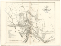
DESCRIPTION: A handsome and very detailed plan of the Scottish town of Kirkcaldy. A numbered key identifies 21 prominent public places. Engraved by T. Clerk.<br><br> Below is a portion of the descriptive account of the town from the text volume that accompanied the work:<br><br> <I>Kirkcaldy is a Royal Burgh, and Sea-port, in the parish of that name, and County of Fife. The Town consists of one principal Street upwards of a mile in length, and stretching along the foot of a bank, from south to north, with a few parallel and cross streets, diverging from either side of the main street. It lies on the north side of the Firth of Forth, close upon the beach, the road to Dundee, Perth &c. passes through it. Kirkcaldy is three miles east of Kinghorn, thirty-one miles south from Dundee, and thirteen miles north from Edinburgh. The street is very irregular and crooked, in some places it is of a good width, and in others very narrow, the houses in general mean, and built without regard to regularity.</I><br><br> John Wood, 1780/85 - 1847, was a land surveyor from Edinburgh, Scotland and was elected Permanent Director of the Land Surveyors' Society around 1833. He is best remembered for his exceptionally accomplished 'Town Atlas of Scotland' of 1828 containing forty-eight town plans.<br><br> The publication of this atlas, following ten years of toil, was a conspicuous milestone in the history of urban cartography for it contained the first systematic delineations of many Scottish towns. Plans were accompanied by descriptive and historical accounts of their towns. Curiously, however the atlas omitted some towns which Wood had already surveyed and for which he had published individual plans. Also, not all the delineations are from Wood's own surveys. Individual plans could be purchased in local towns and from the Edinburgh bookseller Thomas Brown.<br><br>
ADDITIONAL INFO: Printed on "J. Whatman Turkey Mill 1826" watermarked paper.
CONDITION: Good condition.
REFERENCE:



 Login / Register
 Basket