Price: $5,000.00
SKU: 10432
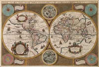
ARTIST: Jodocus Hondius
PUBLISHER: Published by J. Hondius, Amsterdam.
MEDIUM: Copper engraving,
DATE: c.1606.
EDITION SIZE: Image size 14 3/4 x 19 3/4" (37.3 x 50 cm).
DESCRIPTION: Hondius engraved this map for his first edition of Gerard Mercator’s atlas. It was issued in his atlases until 1630. The enlarged North American continent includes many errors, notably the northeast portion in the current U.S., which is badly distorted, and an oddly protruding Virginia coastline. It does have a more accurate depiction of the southwest coast of South America. Various scenes which were taken from the earlier volumes of de Bry’s Grand Voyages adorn this map. The inset in the lower left margin is an intriguing Brazilian native scene, illustrating the method used to make a local beverage. <br><br>
ADDITIONAL INFO: French issue, 1630 (Phillips, Atlases, 441, #160).
CONDITION: Good condition save repair near lower centerfold. Black and white.
REFERENCE: #150 in The Mapping of North America by Philip Burden.


 Login / Register
 Basket