Price: $165.00
SKU: 1800
ARTIST: John Tallis
PUBLISHER: John Tallis & Company, London & New York.
MEDIUM: Handcolored engraving,
DATE: c.1851.
EDITION SIZE: Image size 10 x 13 1/8" (155 x 335 mm) plus margins.
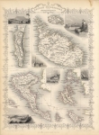
DESCRIPTION: A decorative map which includes an inset map of the island of Mauritius and inset views of Native Village, Madagascar; Point de Galle, Ceylon; Port Louis, Mauritus; North Beach, Prince of Wales Island; and Fall of the River Roche, Isle of Bourbon. This map is from "The Illustrated Atlas and Modern History of the World" Published by John Tallis, J. &. F. Tallis, or The London Printing and Publishing Company. The illustrations are drawn & engraved by H. Winkles, The map is drawn and engraved by J. Rapkin.
ADDITIONAL INFO:
CONDITION: Good condition and color, with the vignettes and border colored.
REFERENCE:


 Login / Register
 Basket