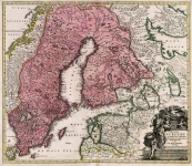
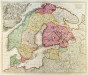
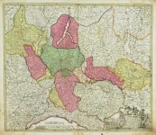
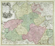
ARTIST: Johann Baptist Homann
PUBLISHER: Johann Baptist Homann, Nuremberg.
MEDIUM: Engraving handcolored,
DATE: c.1720.
EDITION SIZE: Image size 19 3/16 x 22 3/8" (487 x 568 mm) plus margins.
DESCRIPTION: Johann Baptist Homann, a German engraver and publisher who established himself and his family in Nuremberg in 1702. He published his first atlas, "Atlas Novus" in 1707, and in recognition of this achievement, he was elected to the Berlin Academy of Sciences. In 1715 Homann was appointed Geographer to the Emperor. Homann died in 1724 and his business was continued by his family under the name Homann's Heirs into the late 18th century. Homann's map are generally finely engraved, although often in a rather heavy handed style. The normal coloring for his maps is with an attractive wash color with the cartouche left uncolored. This map is unusual in that the cartouche has been handcolored. This is a nicely detailed map of the Lorraine district of north east France.
ADDITIONAL INFO:
CONDITION: Good condition and color.
REFERENCE:


 Login / Register
 Basket