Price: $145.00
SKU: 23531
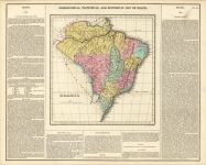
ARTIST: Fielding Lucas, Jr.
PUBLISHER: Published by Carey & Lea, Philadelphia.
MEDIUM: Handcolored engraving,
DATE: c. 1822
EDITION SIZE: Image 16 5/8 x 20 5/8" (42.2 x 52.5 cm) including descriptive text.
DESCRIPTION: Plate No. 49 from "A Complete Historical, Chronological and Geographical American Atlas." The text includes such headings as Situation, Boundaries, and Extent; Face of the Country, Soil, and Productions; Rivers; Climate; and a historical sketch of the country. An interesting and informative map.
ADDITIONAL INFO: This piece is in a 18.5 x 23 inch archival mylar for handling.
CONDITION: Good condition with original wash color. Slight darkening along centerfold.
REFERENCE:


 Login / Register
 Basket