Price: $60.00
SKU: 23656
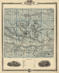
ARTIST: A. Andreas
PUBLISHER: Andreas Atlas Co., Chicago.
MEDIUM: Three-color stone engraving,
DATE: 1875.
EDITION SIZE: Image size 13 x 17" (33.2 x 43.3 cm) plus margins.
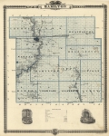
DESCRIPTION: A detailed map from "A. T. Andreas' Historical Atlas of the State of Iowa." On the reverse is a map of Henry County. The map is surrounded by a nice decorative border.
ADDITIONAL INFO:
CONDITION: Good condition save for occasional small tear in the margins.
REFERENCE:


 Login / Register
 Basket