Price: $375.00
SKU: 25662
ARTIST: Philippe Vandermaelen
PUBLISHER: Published by P. Vandermaelen, Belgium.
MEDIUM: Lithograph handcolored,
DATE: 1827
EDITION SIZE: 18 1/2 x 22 1/4" (470 x 565 mm) plus margins.
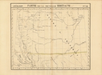
DESCRIPTION: Plate No. 34 from "Atlas Universelle". A beautiful map of Ontario province including a small section of James Bay and northern Lake Superior. Isle Royale is shown as well. This atlas was the first published lithographic atlas.
ADDITIONAL INFO:
CONDITION: Very good condition. Original outline color.
REFERENCE:


 Login / Register
 Basket