Price: $1,200.00
SKU: 27677
ARTIST: Robert Sayer
PUBLISHER: London, Printed and Sold by Robt. Sayer, Map and Printseller…
MEDIUM: Copper plate engraving with outline color,
DATE: 1775
EDITION SIZE: 17 3/4 x 24 1/8" (451 x 612 mm).
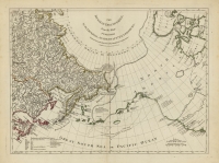
DESCRIPTION: A map centered on the Bering Strait extending to include much of northern Russia, Alaska, and northern Canada from Thomas Jefferys' "The American Atlas: or A Geographical Description of the Whole Continent of America..." Whereas Russia is represented with a high level of detail, North America appears roughly formed with vast blank expanses. An “Explanation of the Russian names” appears in the lower left corner along with symbols denoting the routes of several explorers.
ADDITIONAL INFO:
CONDITION: Good condition and color save for some repaied splitting along centerfold. Original outline hand color.
REFERENCE:


 Login / Register
 Basket