Price: $2,750.00
SKU: 28639
ARTIST: Jacob Monk
PUBLISHER: Published by Jacob Monk, Baltimore.
MEDIUM: Large engraved wall map on linen with original wooden rollers.
DATE: 1853
EDITION SIZE: Overall size 61 x 66". Map 55 1/2 x 59".
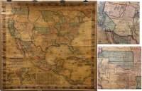
DESCRIPTION: A fine map showing the United States from coast to coast at an important time for trans-Mississippi development. One of two rare editions of this Monk wall map, which was published between 1851-1863. This edition shows a fleeting western Territorial situation with a “Territory of Nebraska as Proposed” encompassing the whole of Kansas and the southern parts of Nebraska created shortly later in 1854 by Congress. Four attempts to organize a single Territory for this area were defeated in Congress, largely because of Southern opposition to the Missouri Compromise. The last of these attempts had nearly been successful and this Monk map most likely shows that final effort. However, after the failure of Congress to approve it, Stephen A. Douglas, chairman of the Senate Committee on Territories, decided to offer territorial legislation making concessions to the South. The bill he reported in January 1854 eventually provided for the creation of two new territories - Kansas and Nebraska - instead of one. The early 1853 edition of this Monk wall map (Rumsey No. 601) has no proposed Nebraska Territory. The map here is the late 1853 edition which Rumsey calls “unusual”. The 1854 edition of this map shows the newly created Kansas and Nebraska Territories and the Gadsden Purchase absent here (Rumsey No. 603). Wheat apparently never saw this late 1853 edition and lists only the early 1853 edition (Wheat No. 794).
ADDITIONAL INFO:
CONDITION: Fair to good condition. Some overall toning and occasional creases. Small 1/2" area of image loss in Canada. Original hand coloring. Overall in good condition for a wall map of the period
REFERENCE: Not in Wheat. Rumsey list No. 602.


 Login / Register
 Basket