Price: $1,950.00
SKU: 30290
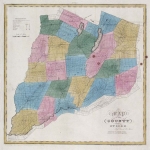
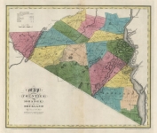
ARTIST: David Burr
PUBLISHER: Published by the Surveyor General... David H. Burr.
MEDIUM: Copper plate engraving,
DATE: 1829
EDITION SIZE: Image size, 13 1/2 x 18 5/8" (341 x 373 mm) plus margins.
DESCRIPTION: A fine map from Burr's "An Atlas of the State of New York Containing a Map of the State and of the Several Counties. Projected and Drawn by a Uniform Scale. . .under the Supervision & Direction of Simon De Witt, Surveyor General. . . ." "It is a magnificent publication and was the second atlas of an individual state ever published." (Ristow). Engraved by Rawdon Clark & Co. Albany & Rawdon, Wright & Co. N. York. This map also includes all of current day Nassau County, Long Island.
ADDITIONAL INFO: This piece is in a 16.75 x 23.5 archival mylar for handling.
CONDITION: Good condition. Original hand coloring
REFERENCE:


 Login / Register
 Basket