Price: $6,000.00
SKU: 31346
ARTIST: J. F. W. Des Barres
PUBLISHER: Published according to act of Parliment Octr. 7, 1777 by J. F. W. Des Barres, Esqr.
MEDIUM: Aquatint & line engraving
DATE: 1777
EDITION SIZE: Four views, overall 19 3/4 x 29 1/8" (50 x 73.9 cm) plus title and margins.
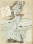
DESCRIPTION: This fine series of views appeared in "the Atlantic Neptune" by Captain Joseph Frederick Wallet Des Barres. It is one of the finest large scale sea atlases of the U.S. and Canadian Atlantic coast line ever produced. The maps in the atlas were produced over six-year period (1775-781), and are well known for their accurate portrayal of various sounds, bays, bars, and harbors, as well as navigational hazards. It was used extensively by the Royal Navy during the American Revolution. This particular chart depicts a series of four panoramic views of the approaches to Boston as they would be seen from the deck of a ship. The titles of each view are, top to bottom, Boston, seen between Castle Williams and Governors Island, distant 4 miles; Appearance of the High Lands of Agemeticus, N.E. with Penobscot Hills, to the Entrance, at 3 to 4 leagues off shore; Boston Bay, the Light House bearing N.W.b.W. distant one league; The Entrance of Boston Harbor.
ADDITIONAL INFO:
CONDITION: Good condition, save for a soft printers crease in the lower view. Three of the four views have original handcoloring.
REFERENCE:


 Login / Register
 Basket