Price: $95.00
SKU: 31577
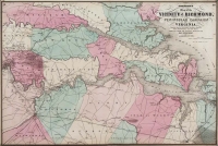
ARTIST: A. Johnson
PUBLISHER: Published by A. J. Johnson, New York.
MEDIUM: Handcolored engraving,
DATE: 1866.
EDITION SIZE: Image size 21 5/8 x 15 1/4" (54.8 x 38.7 cm) plus margins.
DESCRIPTION: A handsome map from "Johnson's New Illustrated Family Atlas of the World...." This detailed map notes railroad lines, lakes, rivers, counties and principal cities. The map is surrounded by a finely engraved calligraphic border. A nice bright and well colored impression.
ADDITIONAL INFO: This piece is in a 19.75 x 27.25 inch archival mylar for handling.
CONDITION: Good condition and color.
REFERENCE:


 Login / Register
 Basket