Price: $950.00
SKU: 32461
ARTIST: Thomas Jefferys
PUBLISHER: Published by Laurie & Whittle, No. 53 Fleet Street, London.
MEDIUM: Copper plate engraving
DATE: 1794
EDITION SIZE: Paper size 24 x 18 1/8" (609 x 463 mm) plus margins.
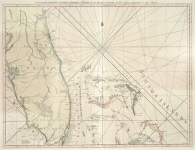
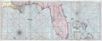
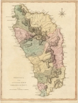
DESCRIPTION: St. Vincent from an Actual Survey Made in the Year 1773 by Thomas Jefferys, Published 1794 in The West Indian Atlas. This beautifully engraved map of the island of St. Vincent, published in 1794 by the renowned British cartographer Thomas Jefferys, is a cornerstone in the visual history of the Caribbean. Issued in The West Indian Atlas, a monumental work intended to aid navigation and colonial administration, the map was based on a detailed survey completed in 1773, shortly after the Treaty with the Caribs formally ceded parts of the island to British control. The map reflects a delicate political and cultural moment in time, capturing the early structuring of parishes and settlements during a period of expanding British influence. Every river, town, and geographic feature is rendered with precision, and the island’s undulating terrain is conveyed through fine hachuring, evoking both its rugged beauty and strategic importance. Jefferys, known as "Geographer to the King," was one of the most influential mapmakers of the 18th century, and his work on the West Indies set a high standard for accuracy and artistry. This particular map stands out for its clarity and detail—it not only charts the coastline with navigational care but also provides an interior portrait of an island in transition, just emerging from indigenous sovereignty into the structure of colonial governance. With its elegant engraving, historical depth, and documentary significance, this map is as informative as it is visually compelling, offering collectors, historians, and admirers of fine cartography a rare glimpse into a pivotal chapter of Caribbean history.
ADDITIONAL INFO: This piece is in a 21.25 x 27.5 inch archival mylar for handling.
CONDITION: Fine condition. Original hand coloring.
REFERENCE:


 Login / Register
 Basket