Price: $500.00
SKU: 34139
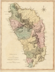
ARTIST: Thomas Jefferys
PUBLISHER: Published by Laurie & Whittle, London.
MEDIUM: Copper plate engraving,
DATE: 1794.
EDITION SIZE: Image size 18 1/2 x 24 3/8" (46.8 x 61.9 cm)
DESCRIPTION: Martinico, Done from Actual Surveys and Observations made by English Engineers whilst the Island was in their Possession, by Thomas Jefferys, 1794. This finely engraved map of Martinique was produced during a pivotal moment in colonial history, when British forces briefly held the island during the 18th century. Issued as part of The West Indian Atlas—Jefferys’ authoritative maritime atlas—this separately published version is segmented and mounted on linen, a format favored for ease of handling and preservation aboard ship or in the field. The map captures Martinique in exquisite detail, charting its towns, rivers, roads, and anchorages. In the lower left, an inset of “Cul de Sac Royal” (now Fort-de-France Bay) emphasizes the island’s vital harbor. Thomas Jefferys, Geographer to the King, was among Britain’s most skilled and influential mapmakers. His work was central to Britain’s understanding and navigation of the Caribbean during the age of empire. This map, based on firsthand British military surveys, provides not only a technical rendering of the island but also a window into the colonial tensions and territorial ambitions of the time. A superb blend of artistry, accuracy, and historical significance, this is a compelling piece for collectors of fine cartography and West Indies history alike.
ADDITIONAL INFO: This piece is in a 20 x 26.25 inch archival mylar for handling.
CONDITION: Very good condition. Black & white.
REFERENCE: Sellers and Van Ee #2063


 Login / Register
 Basket